Filter By
95 Repositories
JavaScript Maps
:ukraine: A self-hosted app for keeping track of employee wellbeing and dislocation during the Russo-Ukrainian war, with an interactive map.
Helping organizations stay together and help their members in times of disaster On February 24th, 2022, the lives of the entire Ukrainian nation were
This is the leaflet plugin for GeoServer. Using this plugin user can have access to wms and wfs request easily.
Documentation leaflet-geoserver-request This is the plugin for Geoserver various kind of requests. Using this plugin, we can make WMS, WFS, getLegendG
(IDW) Interpolated Heatmap Layer for mapbox-gl

Mapbox :: Interpolated Heatmap(s) InterpolateHeatmapLayer is a minimalist JavaScript library for rendering temperature maps (or interpolate heatmaps)
Pixel based heatmap with html5 canvas.
heatcanvas Note that this project is no longer active maintained. Please let me know(file an issue or send me email) if you are interested in taking o
Implements the tilelive API for generating vector tiles from PostGIS
tilelive-postgis Implements the tilelive API for generating mapnik vector tiles from PostGIS. Installation npm install @mapbox/tilelive tilelive-postg
Lightweight GIS toolbar developed for OpenLayers

OpenLayers Toolbar - OLTB Lightweight GIS toolbar developed for OpenLayers 6.13.0. The toolbar can be filled with any number of tools and can be used
UNMAINTAINED Open source JavaScript renderer for Kartograph SVG maps
This project is not maintained anymore. Here are a few reasons why I stopped working on kartograph.js: there's no need to support non-SVG browsers any
re:places is a serverless database of 41,000 global cities for your browser
An in-cache, searchable database of 41,000 global cities. It’s designed as a light-weight polyfill for ‘cities’ in Algolia's places API, for when it sunsets in May 2022
Node.js REST API for PostGres Spatial Entities. AKA: SpatialServer
PGRestAPI (a.k.a. Chubbs Spatial Server) Overview Node.js REST API for PostgreSQL Spatial Tables. An introduction to PGRestAPI can be found here A few
This is a collection of over two hundred code samples an growing for the Bing Maps V8 web control.
Bing Maps V8 Code Samples This is a collection of over a hundred code samples for the Bing Maps V8 web control. These samples have been collected from
Echarts画中国地图所使用的各省份地图数据。包含最新的行政规划。如,西藏那曲地区改为那曲市,山东济南合并莱芜。 后续会根据最新的区域行政规划,及时更新。
echarts-provinces-map 本项目是Echarts画中国地图所使用的各省份地图数据。包含最新的行政规划。如,西藏那曲地区改为那曲市,山东济南合并莱芜。 后续会根据最新的区域行政规划,及时更新。 因为Echarts5.0及以后的版本将不在维护省份地图数据,所以新的行政区域调整将不会在老
An online tool to generate and visualize maps for irregular and/or gapped LED layouts, for use with FastLED, Pixelblaze and other libraries.

An online tool to generate and visualize maps for irregular and/or gapped LED layouts, for use with FastLED, Pixelblaze and other libraries.
JavaScript WebGL 3D map rendering engine

VTS Browser JS is a powerful JavaScript 3D map rendering engine with a very small footprint (about 163 kB of gziped JS code). It provides almost all f
jQuery plugin for zooming images on mouseover.
About Zoom A small jQuery plugin for zooming images on mouseover or mousedown. See the project page for documentation and a demonstration. Released un
A memory-efficient GeoJSON representation.
memory-geojson (experimental 🧪 ) A memory-efficient GeoJSON representation. This is not a new format. It's not meant to be serialized, and it doesn't
This project contains the TypeScript definitions for the Bing Maps V8 Web Control.

Bing Maps V8 TypeScript Definitions These are the official TypeScript definitions for the Bing Maps V8 Web Control. These can be used to provide intel
Mapbox Visual for Power BI - High performance, custom map visuals for Power BI dashboards
Mapbox Visual for Microsoft Power BI Make sense of your big & dynamic location data with the Mapbox Visual for Power BI. Quickly design high-performan
Simple location picker on Leaflet map
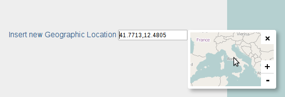
Leaflet Location Picker Simple location picker with Leaflet map Usage: labelInsert a Geo Location input id="geoloc" type="text" value="" / /lab
Geokit - is a command-line interface (CLI) tool written in javascript, that contains all the basic functionalities for measurements, conversions and operations of geojson files.
Geokit Geokit is a command-line interface (CLI) tool written in javascript, that contains all the basic functionalities for measurements, conversions
AngularJS directive to embed an interact with maps managed by Leaflet library
Angular Leaflet Why the fork? While we are grateful for all the original work at tombatossals/angular-leaflet-directive. We need to be able to operate
Super Low-Level Raster Reprojection and Resampling Library
geowarp Super Low-Level Raster Reprojection and Resampling Library install npm install -S geowarp usage const geowarp = require("geowarp"); const proj
Downloads satellite images from Google Maps, only slightly illegal.
Google Maps Satellite Downloader This is a script to download satellite images from Google Maps. The below mentioned optimization system requires that
A modern study React component of leaflet draw for react-leaflet

React Leaflet Draft A modern study React component of leaflet draw for react-leaflet React component of leaflet-draw for react-leaflet Table of conten
Information about the application internals and instructions on how to run it can be found in our Technical Documentation.

Swisstopo Showcases Welcome to our approach on bringing geodata closer to the user. This is our semester project during our Bachelor studies at the Be
Utility to warm up your tile server cache
TileMantle A tool to warm up your tile server cache. Give it a URL template, geometry, and list of zoom levels and it will request tiles incrementally
modern parser & stringifier for WKT, EWKT, and GeoJSON
betterknown betterknown development is supported by 🌎 placemark.io I wrote wellknown, a WKT parser and stringifier, eons ago. It's still sort of popu
🏸 A simple plugin for image zooming without dependencies ~1.65KB gzip
ZOOOM.JS A simple plugin for image zoooming without dependencies. Only pure javascipt. Installation CDN JavaScript script src="https://cdn.jsdelivr.n
Reproject GeoJSON. Works Offline.
reproject-geojson Reproject GeoJSON features Works Offline Pure JavaScript Cross-Platform (NodeJS or Browser) install npm install reproject-geojson us
WMS server using node-mapnik
landspeed.js A simple WMS server written in node.js Only supports WMS 1.1 GetMap requests (bbox, width, height, and srs). Requirements Node.js 0.10.x
Utility to explode ArcGIS geometries into individual, component geometries
@odoe/explode A small utility to explode ArcGIS geometries into individual, component geometries. Inspired by the Explode utility of ArcGIS Desktop Po
Fast Map built for keys that are always fixed size uniformly distributed buffers.
turbo-hash-map Fast Map built for keys that are always fixed size uniformly distributed buffers. npm install turbo-hash-map Uses a prefix trie to map
Greasemonkey script to allow marking items on the interactive map of Elden Ring as completed.
Greasemonkey script (or Tampermonkey) to allow marking items on the interactive map of Elden Ring as completed. The interactive map is a Fextralife-project, all credits for the map go to them.
🙃 Life is too short to set-up an account on GCP

Google no-API tools 🙃 Life is too short to set-up an account on GCP Install npm i @brunoluiz/google-no-api-tools # or yarn add @brunoluiz/google-no-a
Generates an embeddable map that displays business info from an OSM object id.
# OSM Business Card Generates an embeddable map that displays business info from an OSM object id. Loads object type (n/w/r) and id from url parameter
Find a restroom near you in NYC 💩
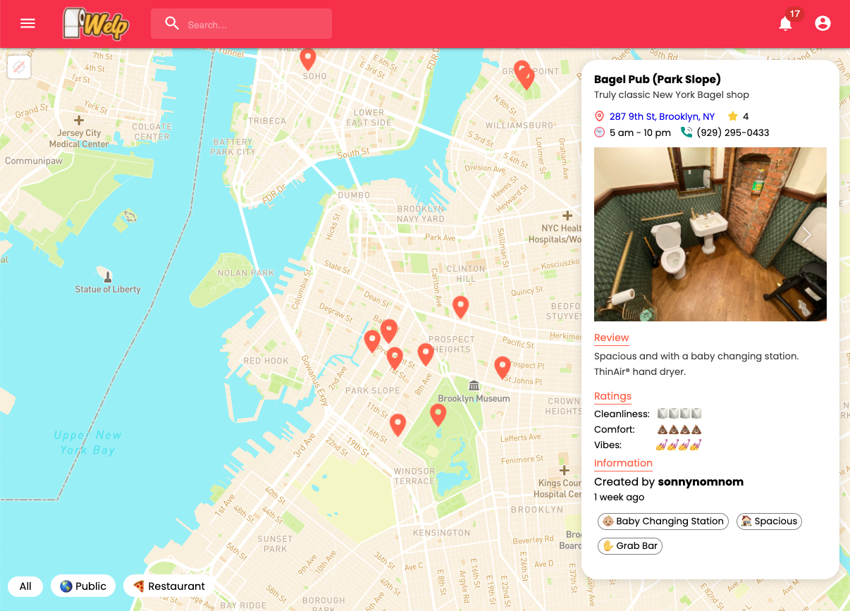
Welp Find and review restrooms near you (NYC) In one terminal tab: cd frontend yarn install yarn start In another: cd backend yarn install yarn start
A library that makes Image Map Area responsive
A library that makes Image Map Area responsive
GeoIP-NodeJS - Basic GeoIP coded on NodeJS for educational purposes.
IP-Tracker NodeJS Basic GeoIP coded on NodeJS for educational purposes. Tool coded on nodejs that grabs info about an IP Address. Install and Usage np
Write or parse GeoJSON as YAML
geoyaml Write or parse GeoJSON as YAML. Like this: type: FeatureCollection features: - geometry: type: Point coordinates: - 37.9
Demo of Singapore buildings 3D tiles from OneMap on Mapbox GL JS.

Singapore buildings 3D Tiles from OneMap 3D on Mapbox GL JS This is a demo of Singapore buildings 3D tiles from OneMap 3D on Mapbox GL JS. Development
This map is tracking the position of ISS(international space setallite) at every 1 second. I use Nasa's "where the iss" API and "Leaflet.js" for the map.
ISS-tracking-map About This map is tracking the position of ISS(international space setallite) at every 1 second. I use Nasa's "where the iss" API and
the easiest way to use Google Maps
Important If you're developer, I'm moving gmaps.js to NPM, you can give your opinion and check the migration progress in Issue #404 gmaps.js - A Javas